escutcheon

Old Burlington Mall

Off in a corner of a parking lot of the Executive Office Park in Burlington, Massachusetts there is a small waterfall where a little stream emerges out from under Mall Road and tumbles into what, for all intents and purposes, is a drainage ditch.1 It’s a bit remarkable that in the otherwise dehumanizing surroundings of a typical suburban industrial park there remains this small remnant of relatively untouched landscape— such as it is.

Burlington Mall

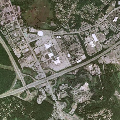
Site of the Burlington Mall; Burlington, MA.

My father talks about hunting in the area as a kid, of course long before the Burlington Mall and Route 128 were put in, when this area was what he thought of as the middle of nowhere. Burlington is currently a modestly sized suburb of Boston with a population of around 23,000, but back before it was tied into the national highway system, it hovered around 1000.

Burlington 1946

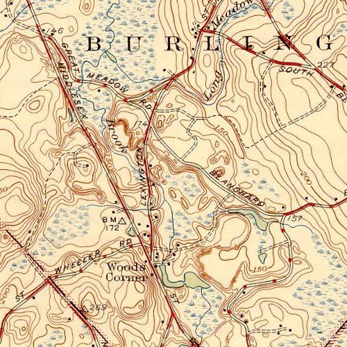
Site of the Burlington Mall; Burlington, MA, 1946 prior to the construction of Route 128.

Looking at some old USGS maps of the area shows just how much things of changed. The Vine Brook has been completely covered by the mall itself - and emerges out on the other side of the Vine Brook Plaza - another bit of development named in typical fashion after the very thing it has helped destroy… The waterfall is part of the Long Meadow Brook—which has more or less maintained its original course, although straightened along the edge of the parking lot before passing back under the road where it eventually joins with the Vine Brook before merging with the Shawsheen River.

Burlington

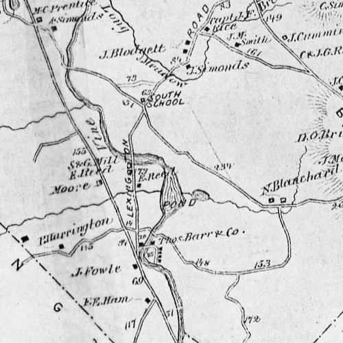
Site of the Burlington Mall; Burlington, MA, c. 1870.

When 128 and the Mall were put in, a number of streets where reconfigured, including the location of the old South School at the junction of Blanchard Road and Lexington Street.

South School

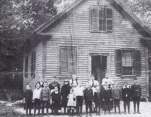
South School in Burlington, MA. Now a parking lot outside of Sears.

The only picture shows the old building in a verdant, rural setting—basically the antithesis of what is now there: the parking lot of the Sears Home and Garden Center.

1 Here is a picture of the falls itself. The flow is unusually high here because of recent rains.

Long Meadow Brook Falls

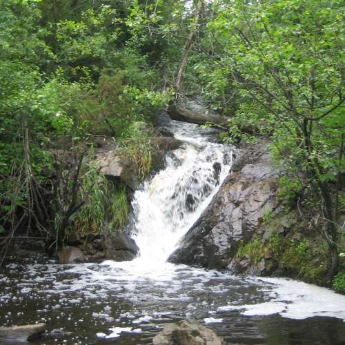
Long Meadow Brook Falls.

A file, viewable in Google Earth, showing the maps above laid out over the modern terrain is available here.

A map showing the precise location of the falls is here. In the satellite view, the arc of the brook can be easily made out even though it is obscured by vegetation.

A short video clip that captures some of the majesty of the falls is here.

» Posted: Tuesday, June 9, 2009 | Comments (13) | Permanent Link
fleuron

Comments

1995 I participated in a volunteer water monitoring program along tributaries of the Shawsheen River as the Vine Brook Stream Team Leader. Along with over 120 volunteers,we took water samples twice a month. We had 3 major rain events that caused that little waterfall by the old Little Executive Center to fill from 3” to 6’. It took a rope and several people to lift my husband (in his fishin’ waders & yellow slicker) from that sample site. Vine brook starts in Lexington Center underground and appears near Hanson ave. (where a gas leak blew up a house OMG )and continues behind a nice neighborhood to re-appear across the Market Basket parking lot. It then follows Middlesex Tpk behind the many fastfood establishments (carrying all the trash with it) to the wetlands behind Hilton, under Rt.128, around the Burl Mall & NEEP. There are active groups monitoring the habitat as well as water quality throughout the seasons. Shawsheen River Watershed & Merrimack River Watershed are both active in these areas and welcome volunteers and contributions. We keep a close eye on re-development projects to preserve these areas!

» Posted by Andrea Tracey on June 14, 2009 09:08 AM

Hi! Don’t you have any photos of that little waterfall itself you are talking about? I cannot distinguish it on the maps you have posted along with the article.

» Posted by Jean Célibataire Endurci on June 24, 2009 01:24 AM

Aha, now I get the full picture. It is indeed surprising to see a corner of wild nature along with malls and other man-made structures. I checked out the Google earth map as well and u are right, it is obscured by vegetation. Nevertheless, thanks for updating!

» Posted by Jean Célibataire Endurci on June 25, 2009 04:16 AM

This is totally fascinating. What an interesting insight into the history of the place. Where did you get the old pictures of the school from? It’s also interesting to see the sharp tension between keeping nature as it is versus the need for society to expand and grow into a more developed culture.

» Posted by Ginny Hestia on September 29, 2009 10:02 AM

wow! This a fantastic entry. I find it totally interesting. I have to ask u too… where did u find the documentation? The pics are great! I´ve never been there but after reading this I want to go!

» Posted by Adela Amor on October 14, 2009 08:10 AM

For over 35 years ive been trying to find someone i lost track of back in 1955. Is there any way you could help me find her? I know Woburn has and is growing very fast! Please email me back.
P.S.
To anyone reading this write me.

» Posted by Robert Smith on November 15, 2011 11:11 PM

Hello! Could you tell me if there was a resturant named “The Mayflower” on the site before it was a Mall? I can’t seem to find any info. online Thanks so much. What a great article!

» Posted by Misty on April 6, 2012 11:31 PM

My mother’s family lived in Somerville back in the 20s and 30s and had a shack in Burlington as their summer getaway(which is now the house my Mom still resides). Most summer homes have a place to swim(Nutting Lake was big in Billerica back then). Well my mom and her brothers and sisters used to walk to Vine Brook and swim in that, across from where the Fire Station is now on Terrace Hall. They called it the “swimming hole.” Imagine that? I love when she talks about those days.

» Posted by dave dee on August 25, 2012 07:09 PM

great work of history…………yes,the old town has changed since the early fifties……i recall fishing in the old swimming hole on vine brook and terrace hall………………

» Posted by CARL JOHNSON on May 25, 2016 12:53 AM

I have included a link to this page on my website. I think the classmates will enjoy it. Our 50th reunion is coming up.

» Posted by Joe Bell on March 28, 2017 12:18 PM

I have included a link to this page on my website. I think the classmates will enjoy it. Our 50th reunion is coming up.

» Posted by Joe Bell on March 28, 2017 12:18 PM

thanks for posting these great pics of old Burlington, I was lucky enough to grow up in the 60,s and 70,s off rte 62, my friends and I were able to explore all those great natural places before progress moved in, Burlington has both hills with gorgous hardwoods, and beutifull lowlands , wich on the west side of burlinton center you have the 3 brooks that make up the Ipswich river,the old sawmil off Burlington center , has some of the best hardwoods in the state, all the hickorys, ashes, maples,oaks, and of course, all of the birches, from the hills of Burlington, adorn the mansions around the state

» Posted by bruce burrell on November 4, 2017 05:07 PM

My Mother’s family had a cottage on Humboldt Ave. in Burlington. The land and the house my parents build around 1959 are still in our family. Does anybody have pictures or information on Terrace Hall Gardens that used to be a rest home and burned down. My mother and aunts would walk there. The ruins and flowers were joyous to a young kid. I remember the swimming hole also in the street.

» Posted by Walter Bacigalupo on August 13, 2019 05:13 PM
fleuron

Post a comment