
1418 Chinese Map of the World
The moment I saw the recently discovered Chinese map of the world purporting to be a copy of one from 1418, I knew that it is not what it is claimed to be. It may very well have actually been printed in 1763, but I doubt very much the depictions of the Americas are from the early 15th century as the text on the map claims.
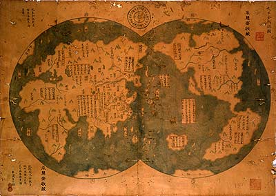
The two details that immediately jumped out to me were, one, the depiction of what appears to be California as an island, and two, the area of the Arctic with what looks like a land mass separated by great ocean streams.
The earliest maps of California from the 16th century depict it correctly—as a penninsula. It wasn’t until the early 17th century that it started to be shown as an island. A recent article in The Economist about this map isn’t very clear on this particular point, seeming to imply in fact that the error is a point in favor of its authenticity. The idea that California was actually an island was based on Antonio de la Ascension’s journal of the 1602 voyage of Sebastian Vizcaino. The first time it appeared as an island was on the title page of Antonio de Herrera’s Descripcion de las Indias Occidentales (1622).
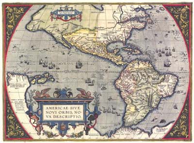
Notice here on Abraham Ortelius’, Americæ Sive Novi Orbis (1587), that California is shown correctly:
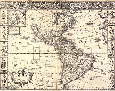
But by the 1630s many of the great Dutch and English map makers began to incorporate the error first shown by de Herrera. Here is an example from John Speed’s Atlas based on Abraham Goos, America (1626)
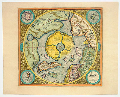
The map’s depiction of the Arctic also bears an interesting resemblance to Gerhard Mercator’s maps showing a northern land with great ocean streams emerging from the pole. Mercator had incorporated mythologies of an open polar sea with a great black rock at the pole itself. For example, Mercator, Septentrionalium Terrarum descriptio (1595)
I believe these details show that the Chinese map has actually incorporated the same errors that are depicted on European maps of the 17th century.

Mind Your Manners
The Renaissance saw a rise in the appreciation of manners and respectable behavior as the growth of cities and trade brought together men of diverse backgrounds. This led to the publication of many books on the subject, even though the topic itself may have been seen as somewhat crass. As Erasmus says in De Civitate:
“I do not deny that external decorum is a very crude part of philosophy, but in the present climate of opinion it is very conductive to winning goodwill.”
Still, this doesn’t prevent one from looking on with a sophomoric appreciation at some of the great minds of the 16th century opining on such subjects as sneezing and farting:
“When you have blown your nose, you should not open your handkerchief and inspect it, as though pearls or rubies had dropped out of your skull.”
Giovanni della Casa, Il Galateo (1558)
“There are some who lay down the rule that a boy should refrain from breaking wind by constricting his buttocks. But it is no part of good manners to bring illness upon yourself while striving to appear polite. If you may withdraw, do it in private. But it not… cover the sound with a cough…, it is more dangerous to refrain from breaking wind than it is to constrict the bowels.”
Desiderius Erasmus, De Civitate Morum Puerilium (1530)
Science at the Limit (Part 1)
Here is an amazing piece of recent scientific analysis. What I find so striking about this is the untold number of years that must have gone into accumulating the dataset that is examined here.
Richard A. Muller, a physicist at Lawrence Berkeley National Laboratory, and Robert A. Rohde, a graduate student in physics at the University of California, Berkeley presented a paper in Nature called Cycles in Fossil Diversity (PDF). In it, they subject the vast amount of accumulated extinction data to Fourier analysis to determine if there are any detectable cycles in the archeological record.
As can be seen is this graph based on their report, two cycles—the most pronounced at 62 millions years, another smaller one at 140 million years—clearly stand out:
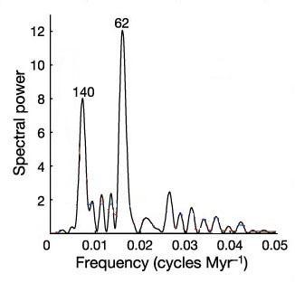
In the latest edition of Brian Hayes’ always excellent column in American Scientist, he takes Muller and Rohde’s original dataset and subjects it to his own analysis. He goes into a bit more detail on some of the assumptions that had been made and ultimately comes up with similar results.
Muller and Rohde speculate that while the cycles may reflect either the integrity of the fossil record itself, or some unknown long-term biological process, it is worth speculating on potential geophysical causes. They consider several different possibilities, all of which have been brought up in the past:
- Passage of the solar system through the arms of the galaxy on 140-million year cycles.
- Oscillation of the solar system through the galactic plane.
- Mantle plume cycles that affect vulcanism.
- Long-period solar cycles that affect weather patterns.
- Orbital perturbations caused by planetary alignments.
- An undetected solar companion star that disturbs the Oort cloud.
- A large, planet-sized Kniuper belt object that disturbs the Oort cloud.
However none of these can definitively be tied to the extinction cycles themselves.
1839 Boston Almanac
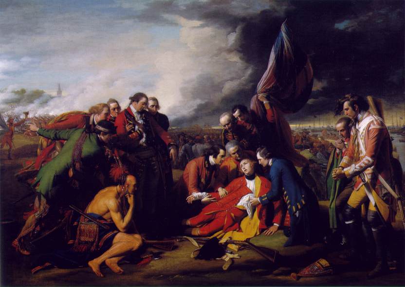
I always like to recommend the book Dead Certainties by historian Simon Schama. It uses the stories of two unrelated fatalities—the death of General Wolfe as depicted in Benjamin West’s famous painting, and the murder of Boston doctor George Parkman at the hands of Harvard Professor John W. Webster—to provide a meditation on the challenges of the opacity of history.
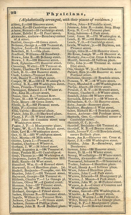
I was able to connect with the doctor’s murder a bit more when I found a copy of an 1839 Edition of The Boston Almanac. It was produced annually by the S. N. Dickerson printing company for several years in the mid-1800s. One page is a listing of all the physicians in the city. It’s interesting to see George Parkman listed there, along with many of the other doctors who would, some ten years hence, be appearing as witnesses in the trial of Professor Webster.
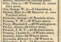
The Almanac makes manifest the provinciality of both the city and medical community as depicted in Dead Certainties. The city’s population was only 78,000 at the time and many of the large-scale land modifications that greatly expanded its area were still decades away. The short page-full of physicians, also makes clear that they all must have known each other reasonably well, which had to have made the trial all that more difficult and sensational for those involved.
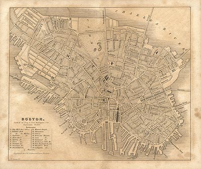
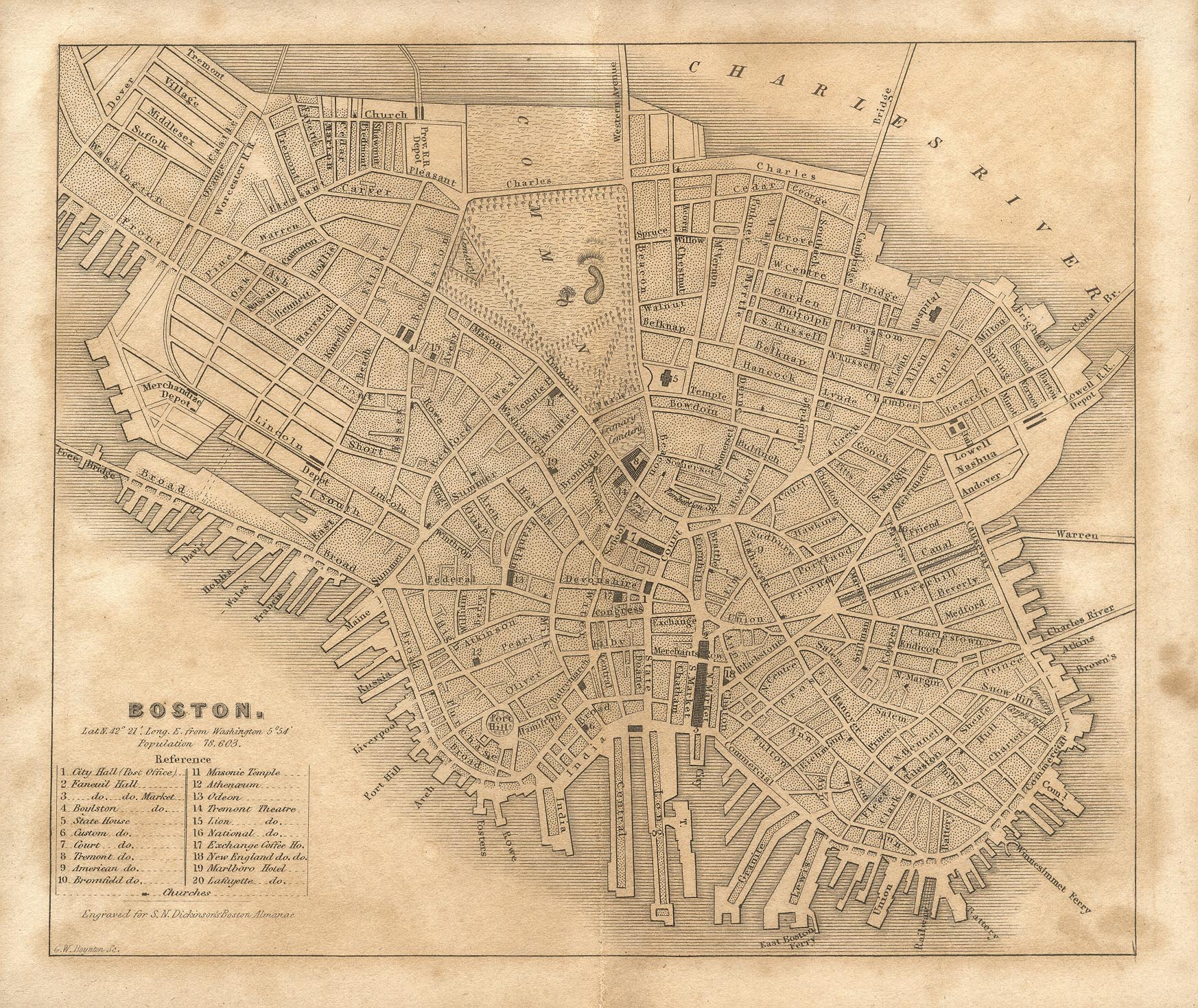
The almanac also contains a nice period map of Boston: