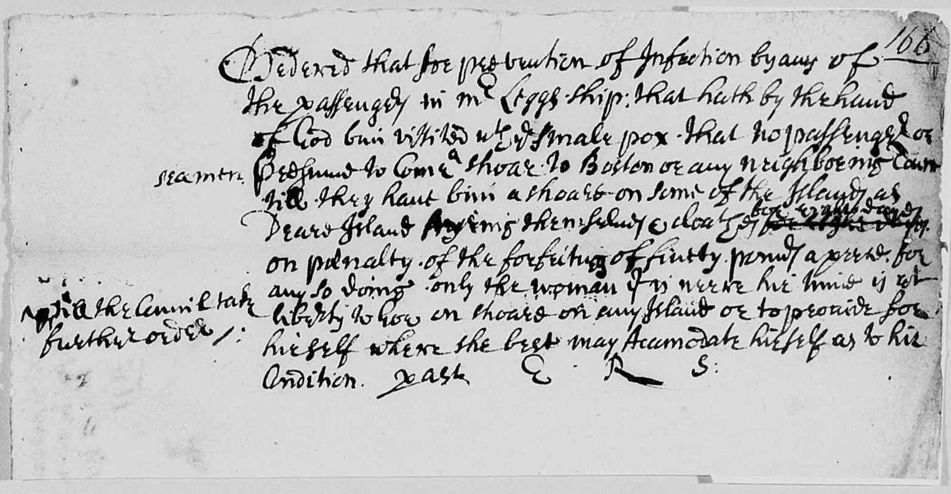
Ordered that for prevention of Infection by any of the passengers in Mr Leggs ship: that hath by the hand of God
been visited with the small pox · that no passengers or persons to come ashore to Boston or any neighboring town
till they have bin ashore on some of the Islands as Deare Island ayring them selves and cloaths for
eyght days on penalty · of the forfeiting of fivety pounds a piece for any so doing · only the women if is neere
hir time is at liberty to gow on shoare on any Island or to provide for hirself where she may Accomodate herself
as to hir condition
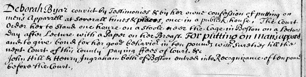
From the records of the County Courts, Suffolk, Massachusetts, November 13, 1691
Deborah Byar convict by Testimonies & by her owne confession of putting on men’s Apparrell at severall times
& places, once in a public house. The Court order her to stand one houre on a stoole neer the Cage in Boston
on a Lecture Day1 after Lecture with a Paper on her Breast. For putting on
man’s apparel and to give bond for her good behavior in ten pounds with sureties till the next court of this
county paying ffees of Court &c
1Lecture
Day was a mid-week gathering, typically on Thursday, when crowds would collect at a meeting house or square
to listen to a sermon
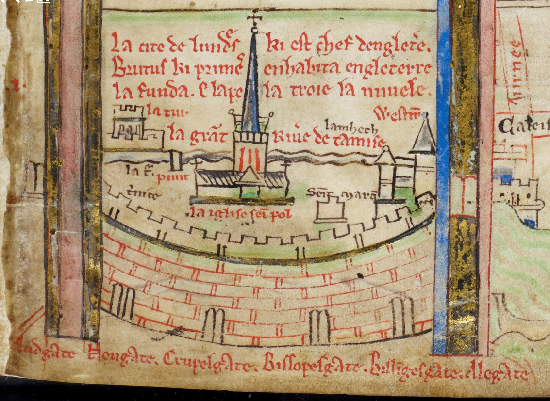
Below are the earliest extant
depictions of London. They are from the front matter of Matthew Paris’ Historia Anglorum and Chronica
Majora written between 1250 and 1259. In both cases they are parts of strip maps showing pilgrimage routes
from London to Rome and on to Jerusalem.
London from Historia Anglorum, MS 14 C VI, f.2r
While the view is obviously very figurative, it nevertheless contains several interesting details that make it
more than a simple iconographic representation.
The text is Anglo-Norman and reads: La cite de lundres ki est chef
de engleterre. Brutus ki premere enhabita ngleterre la funda e lapela troie la nuvele, “The city of London is
the principle city of England. Brutus who was the first inhabitant of England, founded and named New Troy.” The
idea that London was founded by the Trojan Brutus is a
legend first mentioned in the 9th-century but made most famous by Geoffrey of Monmouth in his Historia Regum
Britanniae.
The city is shown to be walled with six named gates:
Ludgate, Neugate (Newgate), Crupelgate (Cripplegate), Bissopesgate (Bishopsgate), Bilingesgate (Billingsgate) and Alegate (Aldgate.) It is situated along the
banks of the Thames (le grat riue de tamise.)
Saint Paul’s Cathedral (la iglise sie pol) dominates the city. Other details (from left to right) include:
la tur, the Tower; la
punt, the bridge; trnite, i.e., la trinite,
for Holy Trinity at Aldgate; across the
river is shown lambeth, Lambeth; seit mara, Saint Martin’s la Grande; and finally Westm,
Westminster.
London from Chronica Majora, MS 26, f.i R
The view from the Chronica Majora may be the older of the two images shown. It is somewhat more fanciful, showing
the city wall as circular and extending beyond the south bank of the Thames, which of course it never did. It
also only shows three, single-arched gates. The view from the Historia Anglorum shows six, although four are show
in the walls, while two are squeezed in along the margin almost as a correction. They are also depicted correctly
as double-arched.
The main text contains the additional sentence, Sis portes i a es murs e la seit, “Six gates are in the
walls along with a seventh.” Suzanne Lewis, in her book, The Art of Matthew Paris in the Chronica Majora, indicates
that this reference to a seventh gate may either be a postern gate north of the Tower, or a barbican built
outside of the Aldgate.
The Chronica view additionally includes a reference to Birmundsee, Bermondsay, outside the wall, and Suuerc,
Southwark, on the south bank, but omits the Historia’s
explicit reference of Westminster.
W. G. Sebald, on a physical manifestation of collective
guilt:
“And indeed, to this day one sees in Belgium a distinctive ugliness, dating from the time when the Congo
colony was exploited without restraint and manifested in a macabre atmosphere of certain salons and the
strikingly stunted growth of the population, such as one rarely comes across elsewhere. At all events, I well
recall that on my first visit to Brussels in December 1964 I encountered more hunchbacks and lunatics than
normally in a whole year.”
…
“At the far end of the room, in the dim light that entered by the Belgian bulls’-eye panes, sat a hunchbacked
pensioner. She was wearing a woollen cap, a winter coat made of thick burled material, and fingerless gloves.
The waitress brought her a plate with a huge piece of meat. The old woman stared at it for a while, then
produce from her handbag a small, sharp knife with a wooden handle and began to cut it up. She would have been
born, it occurs to me now, at about the time that the Congo railway was completed.”
This is a short video I put together of an annular
eclipse of the Sun by Phobos as captured by the
Curiosity rover on Mars; August 17, 2013.
The total elapsed time of the eclipse was about 30 seconds. This was sped up a bit (I put a shorter delay between
images) to make things look a bit smoother. For some reason about 2 seconds of imagery was missing from the NASA
site, so I had to fill in a few frames making things look a bit jagged at the end. I’m sure NASA will be able to
put something nicer together than what I was able to do with some simple tools (e.g., GIMP.) The raw imagery is here.
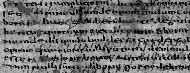
The newly attested Gothic word “atdragan” from Isiah 14:14-15
In the previous image I have highlighted the newly found word “atdragan” from Isaiah 14:14-15.
The fragment was originally of interest due to it being a very early witness to St. Augustine’s “City of God”, an
initial analysis and interpretation of which was published by Armando Antoelli, who provided the original dating.
During a subsequent paleographic analysis by the scholars Maddalena Modesti and Annafelicia Zuffrano, it was
discovered that the Latin fragment was actually a palimpsest with a scriptio inferior in the Gothic language.
Finazzi and Tornaghi have given the Gothic text the name, Gothica Bononiensia, from where the fragment was
found: the Basilica of San Petronio in Bologna. A complete transcription of the Gothic text and images from the
article can be found here.
From a linguistic perspective, one of the more exciting aspects of the find is the discovery of previously
unattested words. Forms of words that had only been reconstructed by linguists were found:
Enhanced photograph of f. 1v, 20-25; Gothic text in lighter gray
The fragment contains a series of biblical passages that jump between the Old and New Testaments. The authors
speculate that the different passage perhaps form the framework for a homily that could be referenced by a
priest. Since some of passages are also found in the Wulfia bible, further study is needed to understand if the
Gothic passages could have been translations based on different Greek or Latin sources than Wulfia’s.
1Gothica Bononiensia: Analisi
linguistica e filologica di un nuovo documento, Aevum, 87
(2013), fasc. 1, pp. 113-155), ISSN 0001-9593
Weather Station “Kurt”, officially
WFL-26 (Wetter-Funkgerät Land-26) was an automated weather station installed in Northern Laborador on October 22,
1943, by a team from the German submarine U-537. It was the only German armed military operation on mainland
North American during World War II.
Northern tip of Labrador. Location of WFL-26
At the outset of World War II, Germany could no longer receive important weather information from the Arctic from
international weather services, and so began a program of installing manned and automatic stations across the
region. These were important for planning air missions over the Soviet Union and northern Europe.
U-537 anchored in Martin Bay, Hutton Peninsula, Northern Labrador
In order to disguise the purpose of the station should it ever have been come across, the crew scattered packs of
American cigarettes and labeled the equipment for the (non-existent) “Canadian Weather Service.” They apparently
needn’t have worried as the station was completely forgotten about. Its existence was not rediscovered until a
historian for Siemens Corporation, who had built the equipment, found it in the company archives. An expedition
to the site was then undertaken in 1981.
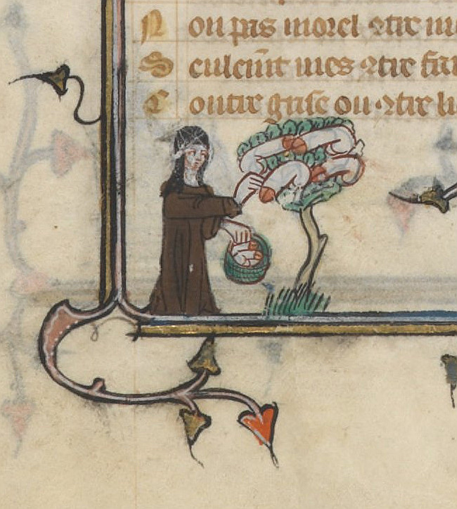
The Bibliothèque nationale de France houses a particularly strange manuscript of Guillaume de Lorris’ and Juen de Meun’s Roman de la Rose: BNF fr. 25526. It is famous for its extensive bas-de-page
images, several of which are of an explicitly erotic nature. One image in particular often serves as an exemplar
of strange medieval marginalia - that found on page 106v, of a nun gathering the fruit of a phallus
tree:
Nun at Phallus Tree. BNF fr. 25526, 106r
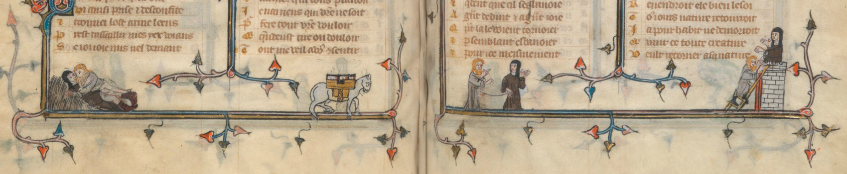
This single image is part of a series on pages 106r and 106v showing a nun and a friar engaged in erotic play.
These same figures appear again on pages 111r and 111v.
Interestingly in her book, “Roman de la Rose and its
Medieval Readers”, Dr. Sylvia Huot of Pembroke
College, Cambridge points out that all of these images are part of a single bifolium; that is, a single double
page that is folded in half and sewn into a quire. From the perspective of the illustrator working on the
bifolium, all eight individual images form one extended series:
111v : 106r
106v : 111r
Because the bifolium if folded in half, the images on the top right (i.e., 111v, Copulation; Mule with phalluses)
becomes the final scene in the series:
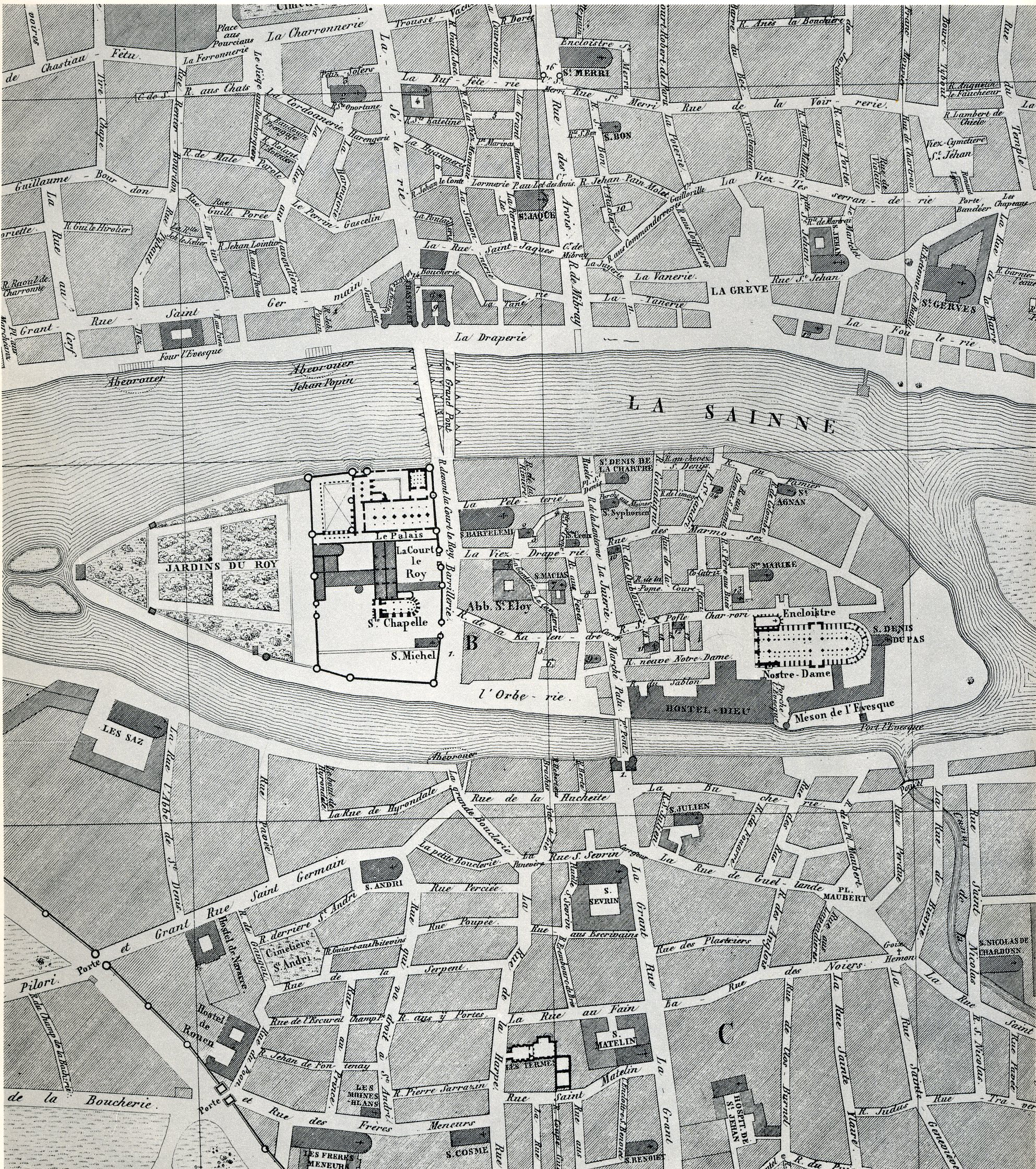
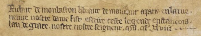
This manuscript was produced by the professional husband and wife team of Richard and Jean de Montbaston working
out of their shop on the Rue Neuve Notre Dame in Paris.
Highlight of 14th century Paris. Rue Nueve Notre Dame, center left
In their book, “Manuscripts and their makers: commercial
book producers in medieval Paris, 1200-1500”, Richard and Mary Rouse, show that the wife, Jean de Montbaston,
was responsible for virtually all the illustrations in fr. 25526 and that interestingly, she was most likely
illiterate(!). Book makers such as the Montbastons worked as speedily as possible and devoted little if any time
for literary interpretations. Often in fact, their cursory view could result in illustrations that completely
misrepresent the text.
Advertisement for Richard de Montbaston. BNF fr. 241
As specific and unambiguous as the tale appears to be, unfortunately, there is no known story which explicitly
describes a friar and a nun as depicted in the bas-de-page images. The Rouse’s remark that the best that could be
said is that they reflect some “bawdy tale” that Jean had perhaps heard during the course of her work.
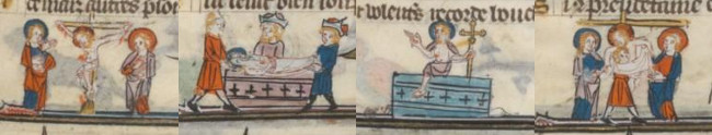
That actual layout of the story is even in question. Many of the illustrations in the book are temporally out of
order. For example, in the interleaving stories of the Passions of Christ and St. Margaret, Montbaston seems to
be aware that the left side of the bifolium will come after the right side when folded and so puts the left side
image:
Descent from the Cross : Crucifixion
Burial : Resurrection
Here the illustrator understands that the Descent from the Cross occurs after the Crucifixion, and so puts that
image to the right, thus when folded, Descent (53v) comes after Crucifixion (52r) . But then, oddly, she
puts the Burial and Resurrection on the other side of that bifolium. This results in a confusing series of
illustrations:
Given what is known about Jean de Montbaston’s literacy and the speed with which she worked, the best I think can
be said is that she managed to get the ordering “correct” this time. Still, what ultimately is the source of
these strange images? Unfortunately, the answer is probably unknowable.
Images have phallus trees have appeared in other contexts, e.g., The Massa Marittima Mural, but any attempt to find
meaning of them seems to result in series of circular references to the few examples that are known.