
A beautiful image taken by the ESA’s Envisat satellite. On the right (East) is Baffin Island showing Nettilling Lake which drains via the Koukdjuak River into Foxe Basin.
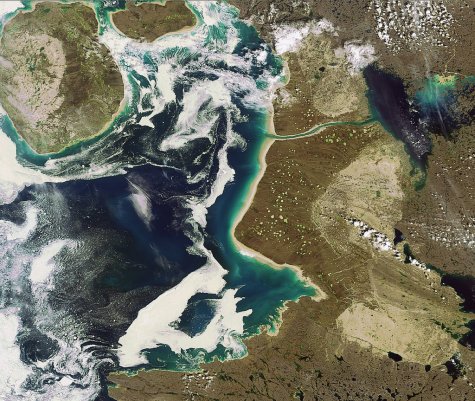
Nettilling Lake is the largest lake on an island in the world. The two islands in the picture are Prince Charles Island (the largest on the left) and Air Force Island which along with Foley Island (not pictured) are the last large landmasses discovered in North America.
They were only found to be separate islands from pictures taken by aerial overflights by the Canadian Air Force in 1948.
Oddly enough these islands are close by another group, the Spicer Islands, rediscovered in 1946.
A Canadian air-borne expedition to the Arctic has rediscovered the Spicer Islands and a number of hitherto unknown islands under the eaves of the continent. The Spicer Islands were discovered in 1897 by Captain Spicer of New Bedford. They were duly marked on maps and charts but had never since been found and there was doubt of their existence.
New York Times, September 10, 1946
